Tornado hits Salisbury, Md.,
Cleanup crews begin work after a potential tornado touchdown Aug. 7 in Salisbury. Video by Ralph Musthaler
Melinda Preller was in her Fruitland home when a likely tornado tore through south Salisbury.
She said she heard about the damage on social media and came out to see what had happened and make sure no one had been seriously injured.
“To be the lunch time part of the day on a weekday, it’s just so devastating,” she said. “To do this kind of damage, it had to have been a severe tornado or hurricane or severe weather. Cars flipped over. I’m just hoping people are OK that there wasn’t anybody in the cars.”
The National Weather Service said Monday it was sending a team to assess the damage in Salisbury, but had yet to officially declare the weather event as a tornado.
However, officials feel like they know the answer.
“From everything we’ve seen, it’s definitely a tornado,” said meteorologist Alec Butner on Monday afternoon.
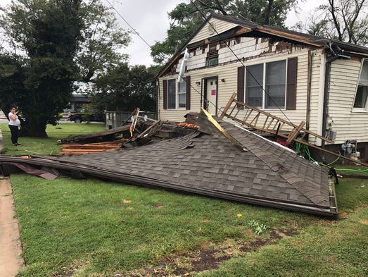
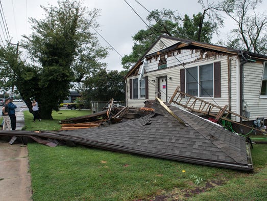
The severe weather did the most damage on the southern part of Salisbury off Route 13 near places such as Dogwood Drive and Roger Street before 2 p.m.
Cars were overturned and trees were split on Route 13 just south of Sea Gull Square, with additional damage to buildings and homes reported across the street from James M. Bennett High School and Rise Up Coffee.
Social media posts and eyewitness accounts showed weather damage to levels usually unseen on Delmarva.
Laura Shriner, who works in Sea Gull Square, was in her car on her lunch break when the peak of the storm hit.

“I saw the leaves going around on top of Cheers, the gas station, and then all of a sudden my car just started flip-flopping from side to side, and I looked over and something hit the power lines. I saw a big white I guess flash, and then it just stopped. It was the craziest.
“I had my phone in my hand, and I was like, ‘Oh, I need to call my boss. I don’t know what to do.’ Everyone was like, ‘You should’ve gotten out of your car.’ It was lifting off the ground side to side. I didn’t think it was safe to get out of the car.”
Anne Heavner, owner of Dressing Room in Sea Gull Square, and Melissa Cullen, one of the store’s employees, were inside the store when the likely tornado came through.
“We saw the first tree, and it wasn’t until a minute later we looked, we see the Sunoco sign, and then we take a bigger look and we saw what happened to the cars,” Heavner said.
Heavner said she’s been at that Salisbury location for two years and has never seen anything like that come through the area.
Although Heavner is used to tornadoes, being from Alabama, this was the first time Cullen had ever experienced one.
“This glass literally — I’ve not felt it in other storms we’ve had — it literally was vibrating, the awnings and the glass. I said, ‘Quick, quick get to the back,’” Cullen said. “It was like something blew up. I thought it was lightning, but I think it was the tree got hit, might’ve hit a pole. I don’t know what the fireball was, but there was a fireball, and then everything went. That’s when I was like, ‘Get back here.’”
Storm coming
The National Weather Service in Wakefield issued a severe thunderstorm warning for central Wicomico County and said at 1:37 p.m. that a severe thunderstorm was located over Salisbury University, moving northeast at about 25 miles per hour, with gusts as high as 60 miles per hour.
“IMPACT … Expect damage to trees and powerlines,” the statement warned.
Wicomico and Somerset counties were under a flood advisory until 4:15 p.m. and flash flood watch until 7 a.m. Tuesday. Accomack and Worcester counties were also under a flash flood watch until 7 a.m. Tuesday.
Sussex County, Delaware, was under a flash flood advisory until 6:15 p.m. Monday and a tornado watch until midnight Tuesday.
Belts of rain hit the area until the late afternoon before taking a break come evening, said James Foster, a meteorological technician, before picking up again overnight.
The weather was being caused by a warm front across the mid-Atlantic region, he said, and moist air that overtook the front.
Last month, a tornado was confirmed in Queen Anne’s County as an EF2 tornado.
On the Enhanced Fujita scale, a 2 rating means winds of between 111-135 miles per hour.
The weather service said the team was sent to Queen Anne’s County to assess damage from the storm that downed trees, collapsed buildings and knocked out power to thousands overnight in the Kent Island area. County officials say one person was injured.
The aftermath
Salisbury University saw the bulk of its damage on East Campus, located along South Division Street, said SU spokesman Richard Culver. On Main Campus, only tree debris was reported.
“There’s been no damage reported on campus at this time,” Culver said.
Avery Street closed due to damage to street lights. SU police were beginning to investigate possible damage to cars parked on East Campus, Culver said.
City officials spent the afternoon walking around Salisbury neighborhoods trying to get a better sense of what happened.
The bulk of the damage was in the Princeton Homes neighborhood, where Mayor Jake Day and Police Chief Barbara Duncan walked the streets and checked in with residents.
“Everybody OK? House OK?” Day called out to one family on Roger Street.
The storm uprooted trees, knocked down power lines and, in a few cases, damaged houses.
On Princeton Street, a huge loblolly pine tree fell on the roof of Francisco Salomon’s house.
“I came back and saw water coming in the house,” he said.
Day and Duncan joined a group of Salomon’s friends and neighbors who were moving the family’s personal belongings out of the house. Their landlord had another house where they could stay in the meantime.
“There was no way they could stay here,” said Michelle Lamb, a property manager with Investment Properties.
City Councilwoman April Jackson said she heard about the damage while she was at Delmarva Power paying her bill. She arrived on the scene soon after.
Throughout the neighborhood, streets were closed to traffic as crews removed tree limbs and worked to restore electricity.